Start of European Farming Culture
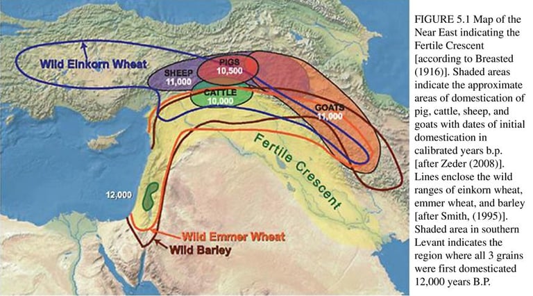
This map shows the location of the earliest agricultural domestications known to archaeology which were apparently done simultaneously by Akkadian speakers living in the northern fertile crescent and Sumerian speakers living in the southern part along the Tigris and Euphrates rivers. The Akkadians included animal husbandry along with crop harvesting. The Sumerians invented the first writing to keep track of their harvests and they wrote in a pictographic form of cuneiform. The Akkadians later adopted that style of writing to their own language as they settled down.
Image from 2005 slide show by Clifton Little. Online at: https://slideplayer.com/slide/13686958/
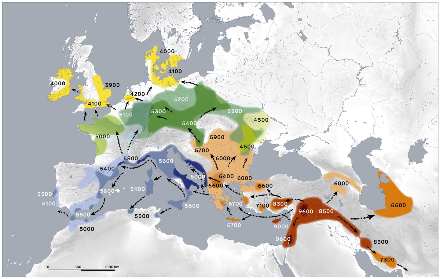
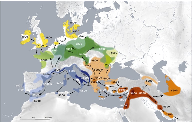
This map shows the spread of farming from the Akkadian fertile crescent as determined by archaeology. These farmers started migrating as the ice started melting from the Ice Age around 9600 BCE. They reached Britain by 4100 BCE. Akkadian is the native language of fertile crescent as revealed by ancient local cuneiform texts. The 2 branches of migration (north and south) through Europe is often reflected in the differing etymologies of the same word (example "cinder").
Map from Gronenborn, D., & Horejs, B. (2023). Online at: https://www.academia.edu/9424525/Map_Expansion_of_farming_in_western_Eurasia_9600_4000_cal_BC_update_vers_2023_1_?email_work_card=title
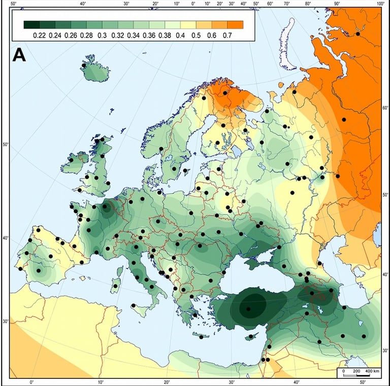

The spread of farming was done by a movement of people as shown by this genetic similarity study for female mitochondrial DNA comparing modern populations with Neolithic burials in the northern Germany cemetery at Derenburg dating to the Linear Pottery culture of 5500-4500 BCE. Mitochondria are cellular organelles which only exist outside the cell nucleus which holds the DNA. They generate energy for the cell. Because of this only eggs contain them and so they can only be passed through the female line.
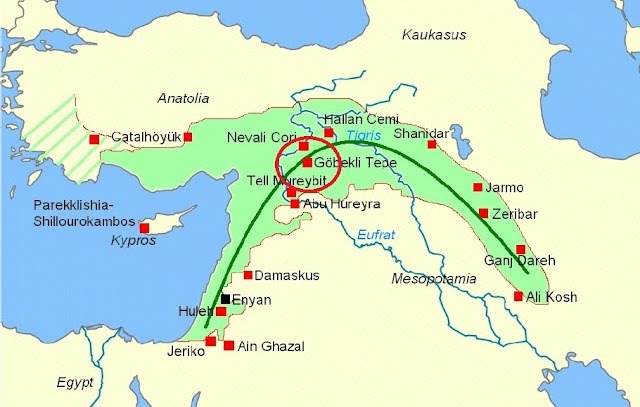
(May 20, 2025) This map shows the location of Gobleki Tepe (9500 BCE to 8000 BCE) along with other important Neolithic Akkadian sites in the highlands surrounding the Tigris and Euphrates river.
Map online at: https://labrumadelolimpo.blogspot.com/2020/07/gobekli-tepe-el-primer-templo-de-la.html

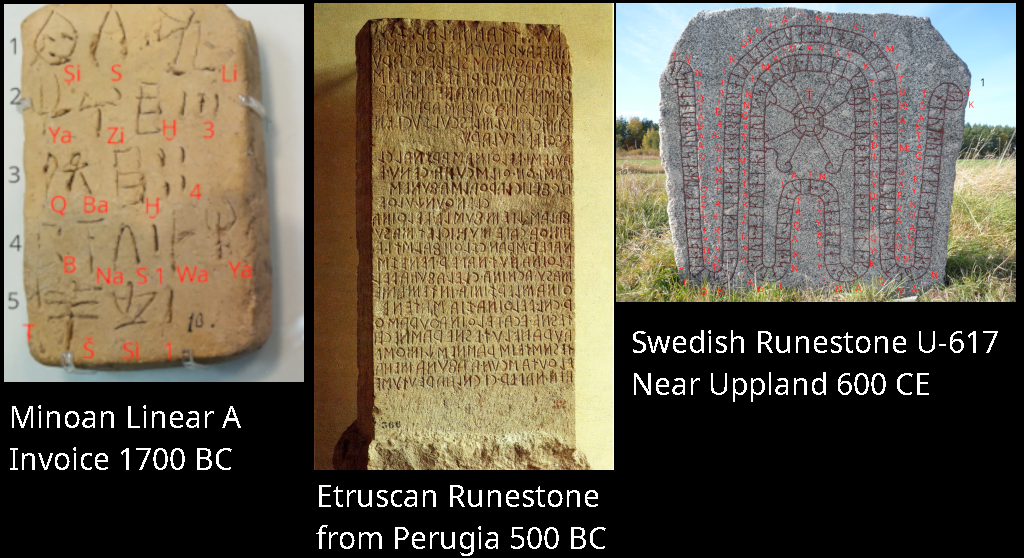
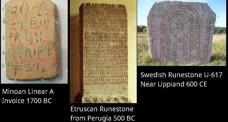
(January 22, 2026) How do we know that the Neolithic farmers were Akkadian speakers? One line of evidence is that all the European runestones were written in Akkadian. Runic texts are texts using words without inner vowels. They were originally more like memory aid devices for trade and temple. This means they only have a simple grammar based upon word position and are not very expressive. It would take Greek and Latin poets, bards, and rhetoricians, to add inner vowels to the runic letters to make the expressive written languages of Europe.
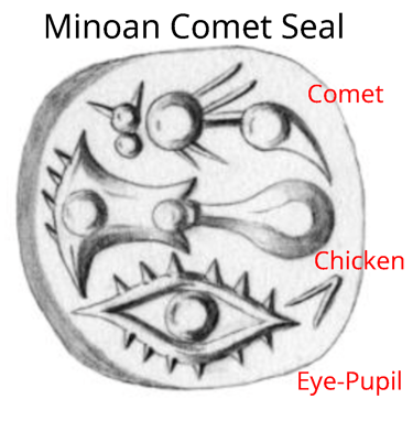
(Revised September 30, 2024) European literacy began in Minoan Crete around 2000 BCE. This is one example of what is called "Minoan hieroglyphics." Some of these signs would end up becoming our alphabet.
Signs
Top sign is an illustration of a comet which may represent a phoneme sign but if so its meaning is unknown. The comet could be Halley's comet which returned most recently in 1836, 1912, and 1988 (every 76 years).
Middle sign is the phoneme Li from the Akkadian word for "chicken" which is "lidanu." The sign shows a chicken head.
Bottom sign is an illustration of an eye-pupil which represents the Akkadian source word A'u meaning "motion powers." These powers were thought to originate with the movements of the heavenly bodies and with inner emotions (eye pupil). The motion power source god was Su who corresponds to both the dark new moon and the pupil of the eye. This is the source word for the letter ayin (').
In Akkadian
"Comet" Li'u
Translation Into English
The comet is laying-out-fate
References
Image from: Decorte, R. P-J. E. (2017) ‘Cretan Hieroglyphic and the Nature of Script’ in Steele, P. M. (ed.) Understanding Relations Between Scripts: The Aegean Writing Systems, Oxford (Oxbow), ch. 3. Online at: https://www.academia.edu/11612879/Decorte_R_P_J_E_2017_Cretan_Hieroglyphic_and_the_Nature_of_Script_in_Steele_P_M_ed_Understanding_Relations_Between_Scripts_The_Aegean_Writing_Systems_33_56_Oxford_Oxbow
© 2022-2026. By David D. Olmsted. All pages licensed under a Creative Commons Attribution-NonCommercial-ShareAlike 4.0 International Copyright. https://creativecommons.org/licenses/by-nc-sa/4.0/