Early Northern European Druid Civilization

The Ister Riverine Trade Route Defined the Northern Druid Migration Route
(February 5, 2026) The northern branch of the Neolithic farmers migrated along the Danube and Rhine rivers. The Danube/Rhine trade route was given the name "Ister" by the Greek historian and geographer Herodotus (c.484–c.425 BCE) in his ‘Histories’, Book II, chapter 33.3 1. Notice "Celts" only referred to the people of Britain in this text. He writes:
“...the Ister flows from the land of the Celts and the city of Pyrene through the very middle of Europe; now the Celts live beyond the Pillars of Heracles (white cliffs of Dover), being neighbors of the Cynesii (Irish), who are the westernmost of all the peoples inhabiting Europe. The Ister, then, flows clean across Europe and ends its course in the Euxine Sea (Black Sea)”.
In Book IV, chapter 49.3, he describes the Ister river trade route as:
“the Ister traverses the whole of Europe, rising among the Celts, who are the most westerly dwellers in Europe, except for the Cynetes (Irish), and flowing thus clean across Europe it issues forth along the borders of Scythia”.
The words "Ister" and "Cynetes" are Druid Akkadian phrases:
Ister is the Akkadian phrase IṢ.T.ER meaning river which "makes scarce the astrology-magic for the harbor" where the harbor is the rain producing sky-shell and a life power. Astrology-magic is a motion/emotion power which shifts fate. So central Europe representing the northern Neolithic farmer migration route did not mix their spiritual power classes like the Druids from Britain, Ireland, and coastal France.
Cynetes is the Akkadian phrase KY.N.ET meaning those who "prod the revelations of the motion-power-boundary" where the boundary for motion powers is the night time sky-shell. So the Irish were known as being astrologers.
References
Eduard Selleslagh-Suykens (April 12, 2017) Herodotus, Pyrene and the Celts revisited. Online at: https://www.academia.edu/24591178/Herodotus_Pyrene_and_the_Celts_revisited_version_04_12_2017
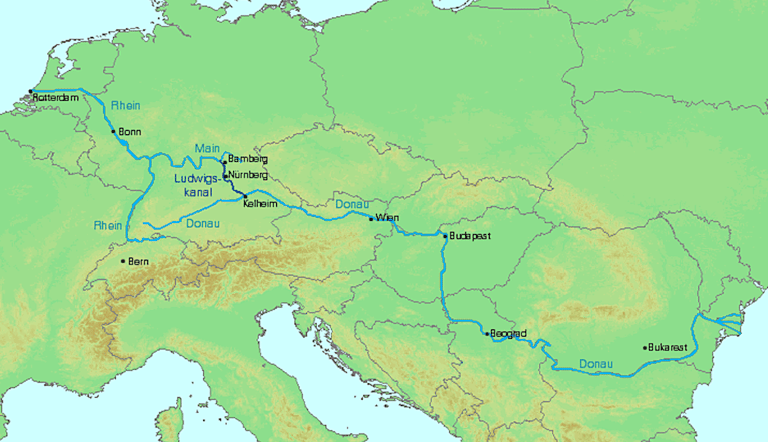
The map above shows the Rhine and Danube rivers connected by the Ludwig canal completed in 1992. Map image from Wikipedia Commons at: https://commons.wikimedia.org/wiki/File:Europa_Ludwigskanal_Rhein_Main_Donau.png
Sicily Of The Southern Druid Branch Was A Tempting Place Hiding Fate Shift Powers
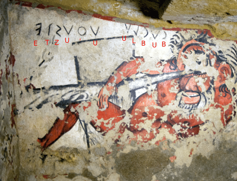
(February 6, 2026) People from the northern branch of Druid culture were generally supportive of astrology-magic which shifted fate while those of the southern branch along the Mediterranean were generally opposed. The Druid god associated with astrology magic was the dark new moon and eye pupil god Su who was also called the "Moon-Eye." The cyclops was his personification. The above photo of Cyclops' eye getting attacked is from an Etruscan tomb from Tarquinia, Italy.
The earliest mentions of Cyclops in Greek literature are in Hesiod and Homer both dating to about 500 BCE. The cyclops in Homer are associated with shepherds in Sicily which is interesting because in Druid runic texts shepherd-priests are the priestly class associated with Su and astrology-magic.
Sicily is the island of fate due to its active volcano, Mount Etna (Druid Akkadian ET.N meaning place of "the boundary's fate-revelations" where the boundary is the sky-shell). The places were fate did not favor the people, like volcanos and deserts were called "libya."
Libyu or Libya: This word is the Druid Akkadian phrase LY.B.Y meaning "Those whom fate does not nourish" which can apply to those who live in the desert or any group barely surviving.
Yet volcanic lands can be a mixed blessing. Despite the death and destruction caused by volcanic eruptions the land around Mediterranean volcanos is extremely fertile. This led to a story in Homer involving the word "Libya" about how appearances can hide an underlying danger from fate.
In Homer's Odyssey the translation of "libya" and "libu" has been problematic. In a quality edition by A.T. Murry (1919) "libya" is translated as "lotus eaters" and "libu" (Akkadian "fate nourisher" is translated as "lotus." While the location of the Cyclops is a bit vague in Homer, the poet Euripides (c. 480–406 BC) locates it on the island of Sicily near Mount Etna: The following is Murry's translation of Homer. The one eyed Cyclops then is seen as a personification of the Druid god called the "Moon-eye" who is the dark new moon god Su associated with the astrology-magic which shifts fate. Homer's text is:
Book 9 - [90] two men I chose, sending with them a third as a herald. So they went straightway and mingled with the Lotus-eaters, and the Lotus-eaters did not plan death for my comrades, but gave them of the lotus to taste. And whosoever of them ate of the honey-sweet fruit of the lotus, [95] had no longer any wish to bring back word or to return, but there they were fain to abide among the Lotus-eaters, feeding on the lotus, and forgetful of their homeward way. These men, therefore, I brought back perforce to the ships, weeping, and dragged them beneath the benches and bound them fast in the hollow ships; [100] and I bade the rest of my trusty comrades to embark with speed on the swift ships, lest perchance anyone should eat of the lotus and forget his homeward way. So they went on board straightway and sat down upon the benches, and sitting well in order smote the grey sea with their oars. [105]
Book 23 - [310] He began by telling how at the first he overcame the Cicones, and then came to the rich land of the Lotus-eaters, and all that the Cyclops wrought, and how he made him pay the price for his mighty comrades, whom the Cyclops had eaten, and had shown no pity. Then how he came to Aeolus, who received him with a ready heart, [315] (http://data.perseus.org/citations/urn:cts:greekLit:tlg0012.tlg002.perseus-eng1:23.310-23.343)
Photo by Rönnlund via Wikimedia Commons, 2012. Letters added by David Olmsted


(February 4, 2026) Map of storm winds shows how the North Sea is shaped like a funnel. Strong winds pile up water on the southern end. Combine this with high tides and those who build cities on tidal flats face disaster.
One of the earliest such storms in modern history was the storm called the Grote Mandrenke (Great Drowning) or Saint Marcellus's flood of 1362 CE. It was an intense extratropical cyclone coinciding with a new moon which swept across the British Isles, the Netherlands, northern Germany, and Denmark (including Schleswig/Southern Jutland). One city it washed away was the medieval English city of Durwich. Another was the pirate town of Raven's Rod on the mouth of the Humber river. These had been built on a coastal sandbar. Around sunrise on January 15, 1362, Durwich was beset by hurricane force westerly winds in excess of one hundred milers per hour. Many were killed as the city was washed out to sea.
For a great YouTube video on such city destroying storms by the History Guy see https://www.youtube.com/watch?v=ZgWsMFS77X8
Grote Mandrenke: 1362 The Great Drowning of Men and the Storm that Reshaped Europe. Online at: https://creativehistorystories.blogspot.com/2020/07/grote-mandrenke-1362-great-drowning-of.html
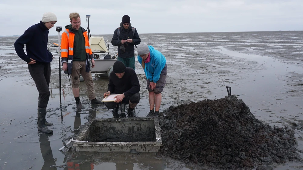
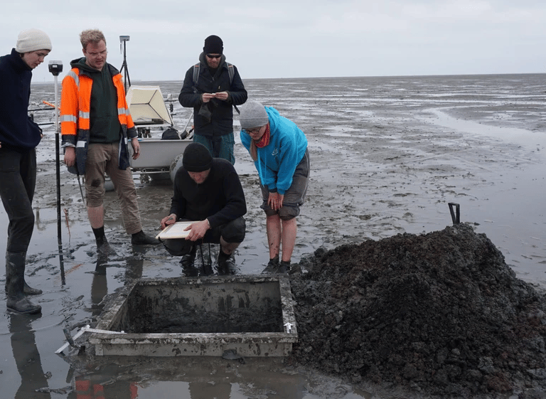
(January 24, 2026) Across the north sea in Frisa another town by the name of Rungholt was also submerged during the same 1362 Great Drowning storm. In this image archaeologists are excavating the remains of its church.
Our source for Atlantis is a book called the Timaeus by Plato written around 360 BCE.
Atlantis, Atlantic: This is the Druid Akkadian phrase A.TL.NT meaning "Those of the Mounds Manifested-from-Nature." This word is also seen in Latin atlanticus and Greek atlantikos which gave the name to the ocean. In Plato's Timaeus (360 BCE) it is spelled as Ἀτλαντὶς νῆσος or "Atlantis Nesos" or "Atlantis the distant" where "nesu" is an Akkadian word meaning "distant."
This is what Plato says about Atlantis in the Timaeus, Section 24e to 25d :
[24e] both for magnitude and for nobleness. For it is related in our records how once upon a time your State (Athens) stayed the course of a mighty host, which, starting from a distant point in the Atlantic ocean, was insolently advancing to attack the whole of Europe, and Asia to boot.For the ocean there was at that time navigable; for in front of the mouth which you Greeks call, as you say, 'the pillars of Heracles,' there lay an island which was larger than Libya and Asia together; and it was possible for the travelers of that time to cross from it to the other islands, and from the islands to the whole of the continent [25a] over against them which encompasses that veritable ocean. For all that we have here, lying within the mouth of which we speak, is evidently a haven having a narrow entrance; but that yonder is a real ocean, and the land surrounding it may most rightly be called, in the fullest and truest sense, a continent. Now in this island of Atlantis there existed a confederation of kings, of great and marvelous power, which held sway over all the island, and over many other islands also and parts of the continent; and, moreover, [25b] of the lands from here within the Straits they ruled over Libya as far as Egypt, and over Europe as far as Tuscany (Etruria). So this host, being all gathered together, made an attempt one time to enslave by one single onslaught both your country and ours and the whole of the territory within the Straits. And then it was, Solon, that the manhood of your State showed itself conspicuous for valor and might in the sight of all the world. For it stood pre-eminent above all [25c] in gallantry and all warlike arts, and acting partly as leader of the Greeks, and partly standing alone by itself when deserted by all others, after encountering the deadliest perils, it defeated the invaders and reared a trophy; whereby it saved from slavery such as were not as yet enslaved, and all the rest of us who dwell within the bounds of Heracles it ungrudgingly set free. But at a later time there occurred portentous earthquakes and floods, [25d] and one grievous day and night befell them, when the whole body of your warriors was swallowed up by the earth, and the island of Atlantis in like manner was swallowed up by the sea and vanished; wherefore also the ocean at that spot has now become impassable and unsearchable, being blocked up by the shoal mud which the island created as it settled down.” You have now heard, Socrates, in brief outline, the account given by the elder Critias of what he heard from Solon;
The Rhine river flows into the North Sea near the city of Rotterdam, forming a large delta with the Meuse and Scheldt rivers before entering into the southern part of the North Sea. The trade route then turns south passing through the narrowest part of The English channel represented by the White Cliffs of Dover. These cliffs were the Pillars of Hercules mentioned in Plato.
The island of Atlantis seems to have been at the entrance to the Thames. It seems to have been part of a Celtic alliance which raided into Greece and Italy around 387 BCE when the Gauls under Brennus sacked the city of Rome.
References
Plato quote is found in: Plato in Twelve Volumes, Vol. 9 translated by W.R.M. Lamb. Cambridge, MA, Harvard University Press; London, William Heinemann Ltd. 1925. Online at: http://data.perseus.org/citations/urn:cts:greekLit:tlg0059.tlg031.perseus-eng1:24e
Picture from: https://www.vice.com/en/article/g5yygw/archaeologists-discover-remnant-of-lost-village-buried-under-the-ocean-for-600-years
Atlantis Was Real and Destroyed By a North Sea Storm
The Druid Halsatt and La Tene Material Cultures Belong To The Northern Druid Branch
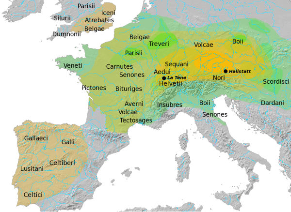
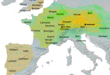
(February 5, 2026) Halstatt material tradition is shown in yellow (1200-400 BCE) while the later La Tene material tradtion is shown in Green (450-50 BCE). The Halstatt tradition was centered on salt mining out of Salzburg, Ausria.
References
Map by Dbachmann via Wikimedia Commons at: https://commons.wikimedia.org/wiki/File:Hallstatt_LaTene.png. He used information from Atlas of the Celtic World, by John Haywood; London Thames & Hudson Ltd., 2001, pp. 30-37.
© 2022-2026. By David D. Olmsted. All pages licensed under a Creative Commons Attribution-NonCommercial-ShareAlike 4.0 International Copyright. https://creativecommons.org/licenses/by-nc-sa/4.0/